The way we monitor locations and travel on Earth has been completely transformed by global navigation satellite systems, or GNSS. These satellite constellations, which include GPS and Galileo, supply critical position data for a wide range of uses, from precise timing in financial transactions to automobile navigation systems. But in order to guarantee the highest level of location accuracy, obstacles including atmospheric delays and signal blockages must be overcome. Nowadays, the Continuous Operating Reference Station (CORS) networks positioning services are amongst the most used ones when the highest positioning accuracy is needed.
Idea behind CORS Network
In most of GNSS applications where precise positioning is required, users usually pair their GNSS instruments with other GNSS instruments, simultaneously observing one or more known position, termed as reference station, and with help of these reference stations estimated corrections to be applied over point of interest or rover position are obtained through Static GNSS Survey or Real Time-Kinematic (RTK) Survey methods.
To liberate users from setting of their own reference station each time they wish to undertake GNSS measurement, Continuously Operating Reference Stations (CORS) has been established, which are not only capable of providing Real Time Positioning Service through RTK/NRTK with an accuracy of ±3cm, but also host an array of different positioning services targeted to cater requirements for different segments of Geospatial and scientific Community.
What is CORS Network?
CORS networks are permanently installed reference stations strategically positioned across a geographic region. These stations are equipped with high-precision GPS receivers and antennas that continuously collect and process GPS data to calculate position corrections. These corrections account for various factors that can affect signal accuracy, such as ionospheric and tropospheric delays, satellite orbit errors, and multipath interference. The data is then transmitted to a central processing facility where it is used to provide real-time, accurate positioning information for a variety of applications.
CORS networks are permanently installed reference stations strategically positioned across a geographic region. These stations are equipped with high-precision GPS receivers and antennas that continuously collect and process GPS data to calculate position corrections. These corrections account for various factors that can affect signal accuracy, such as ionospheric and tropospheric delays, satellite orbit errors, and multipath interference. The data is then transmitted to a central processing facility where it is used to provide real-time, accurate positioning information for a variety of applications.
Characteristics of CORS Network
The CORS network is available 24 hours per day, 7 days a week and 365 days a year.
- CORS stations are strategically distributed across a geographic region to provide comprehensive coverage.
- The CORS network is a multi-purpose collaboration between government, academic, and corporate institutions. The sites are independently owned and operated.
- CORS networks support multiple GNSS constellations, including GPS, GLONASS, Galileo, and BeiDou.
- It is typically used to support a wide range of applications, including surveying and mapping, construction, transportation, and other industries.
- Many CORS networks provide open access to their data, allowing users from various sectors to utilize positioning information for diverse applications.
CORS in INDIA
India has been actively developing and deploying its own CORS (Continuously Operating Reference Stations) network in conjunction with its regional satellite navigation system called NavIC (Navigation with Indian Constellation). NavIC, also known as the Indian Regional Navigation Satellite System (IRNSS), is a constellation of satellites developed by the Indian Space Research Organisation (ISRO) to provide accurate positioning and timing services over the Indian region and surrounding areas.
How CORS network function in India using NavIC?
- India has been establishing a network of CORS stations across the country.
- These CORS stations are equipped with high-precision GNSS receivers and antennas, allowing them to continuously monitor signals from both the NavIC satellites and other GNSS constellations such as GPS.
- The CORS stations collect raw GNSS measurements and transmit them to a central processing facility. At this facility, the raw data is processed using precise algorithms to compute corrections and augmentations for improving the accuracy of GNSS positioning.
- Since NavIC is India’s regional satellite navigation system, the CORS network integrates NavIC signals into its positioning solutions. This integration enhances the accuracy and availability of positioning data, especially in areas where NavIC signals have better visibility than signals from other GNSS constellations.
The corrected GNSS data, including NavIC-based corrections, is made available to users in real-time through various means such as the internet, satellite communication, or radio links. This allows users to access accurate positioning information for their applications, including surveying, mapping, agriculture, transportation, and disaster management.
CORS Network in India — Present
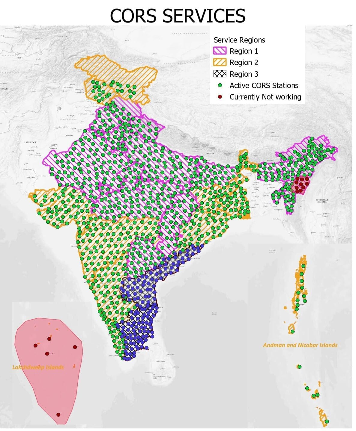
There are two types of Service being made available by Survey of India (SOI):
1. Real Time Positioning Services (RTPS)
- Network RTK Services for 3–4 centimeter real time positioning.
- D-GNSS Services for 30–40 centimeter accurate real time positioning.
2. Reference Data Services (RDS)
- Online Data processing of static observation with respect of CORS.
- Downloading of RAW Data of CORS Stations for processing in user software.
For more precise or scientific applications users can download CORS stations raw observations in non proprietary open RINEX format or virtual rinex data (i.e. RINEX files for a virtual reference station that can then be used for post processing calculations), and use it to process his own GNSS data it his own software.
For accessing all these services users are required to get registered themselves on Survey of India CORS web site, i.e. http://www.cors.surveofindia.gov.in
About SurveyGyaan
SurveyGyaan is an educational initiative under the Surveyaan brand, which is a subsidiary of Nibrus Technologies Private Limited. Surveyaan specializes in drone manufacturing and the development of photogrammetry software.
Surveyaan (Indian Drone Manufacturers): www.surveyaan.com
Surveyaan GeoWorkspace (Photogrammetry Software): app.surveyaan.com
