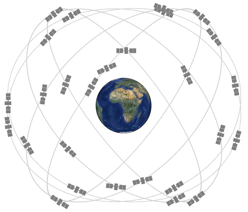
At the heart of GNSS are the satellite constellations, intricate networks of orbiting satellites that work in harmony to provide precise location data. In this blog, we’ll take a closer look at the major GNSS satellite constellations, exploring their features, functions, and the global impact of these constellations.
Several other countries have developed comparable GNSS constellations since the United States deployed the first operational global navigation satellite system i.e., GPS(Global Positioning System).
There are also various GNSS constellations in use around the world which include GLONASS (Global Navigation Satellite System) developed by Russia, GALILEO (Europe’s Satellite Navigation System), China’s BEI-DOU, India’s Regional Navigation Satellite System (IRNSS or NavIC) and Japan’s Quasi-Zenith Satellite System (QZS).
The main reason for all 5 satellite constellations is availability and redundancy. If one system fails, another GNSS constellation can help take over.
GPS (United States)
It was the first fully operational GNSS and remains one of the most widely used globally. It has typically 31 operational satellites. It was created as an independent military navigation system by the Department of Defense (DoD). Before it was made public, great effort was invested into providing high accuracy as well as making it secure against jamming and spoofing attempts. GPS uses the L-Band frequency range of 1176.45 to 1575.42 MHz.
It was the first fully operational GNSS and remains one of the most widely used globally. It has typically 31 operational satellites. It was created as an independent military navigation system by the Department of Defense (DoD). Before it was made public, great effort was invested into providing high accuracy as well as making it secure against jamming and spoofing attempts. GPS uses the L-Band frequency range of 1176.45 to 1575.42 MHz.
GLONASS
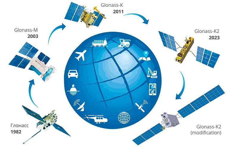
Russia’s Global Navigation Satellite System (GLONASS) is the second navigational system in operation with global coverage and of comparable precision to GPS. GLONASS is operated by the Russian government and became fully operational in 1995. The fully operational system consists of 24+ satellites. It operates in the frequency from 1202.026 to 1600.995 MHz (G1/G2) . In standalone applications, GLONASS doesn’t provide as strong of signal compared to GPS but is a great alternative/backup for GPS. Over the past ten years, Russia began replacing its second-generation GLONASS-M satellites with the more modern GLONASS-K design.
Russia’s Global Navigation Satellite System (GLONASS) is the second navigational system in operation with global coverage and of comparable precision to GPS. GLONASS is operated by the Russian government and became fully operational in 1995. The fully operational system consists of 24+ satellites. It operates in the frequency from 1202.026 to 1600.995 MHz (G1/G2) . In standalone applications, GLONASS doesn’t provide as strong of signal compared to GPS but is a great alternative/backup for GPS. Over the past ten years, Russia began replacing its second-generation GLONASS-M satellites with the more modern GLONASS-K design.
GALILEO
GALILEO is Europe’s GNSS system that is compatible with GPS and GLONASS. It was created by the European Union through the European Space Agency. It operates with 28 satellites. GALILEO provides 3 services
- Open Access Service: It delivers meter-scale accuracy to the public.
- Public Regulated Service: It delivers centimeter-scale accuracy to authorized users.
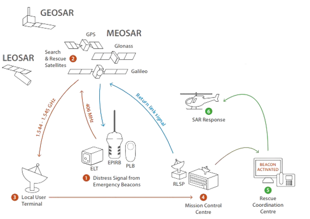
- Search-and-Rescue (SAR): It relays distress messages to European ground stations.
GALILEO is Europe’s GNSS system that is compatible with GPS and GLONASS. It was created by the European Union through the European Space Agency. It operates with 28 satellites. GALILEO provides 3 services
- Open Access Service: It delivers meter-scale accuracy to the public.
- Public Regulated Service: It delivers centimeter-scale accuracy to authorized users.
- Search-and-Rescue (SAR): It relays distress messages to European ground stations.
In early 2023, Galileo’s High Accuracy Service became operational. With sub-meter accuracy in Europe, the new service will support drone navigation, precision agriculture, and other applications. Once the full service goes into effect in 2024, receivers in Europe will get better performance and faster convergence times.
GALILEO operates at a frequency from 1176.45 to 1575.42 MHz (E1/E5a).
BEIDOU
BeiDou is the Chinese satellite navigation system, operated by the Chinese National Space Administration (CNSA).
The first generation was called BeiDou-1 and was mainly used by China and neighboring regions.
BeiDou is the Chinese satellite navigation system, operated by the Chinese National Space Administration (CNSA).
The first generation was called BeiDou-1 and was mainly used by China and neighboring regions.
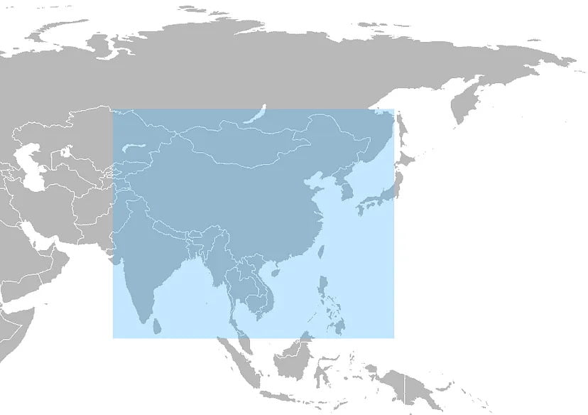
The 2nd generation called the BeiDou-2 has been in use since 2012 which serve users in the entire Asia-Pacific region.
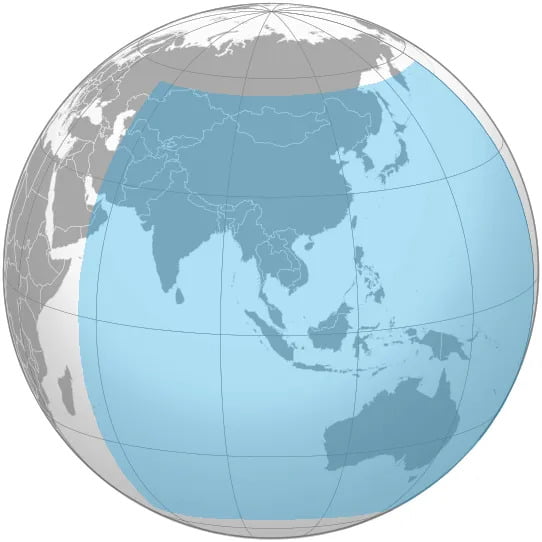
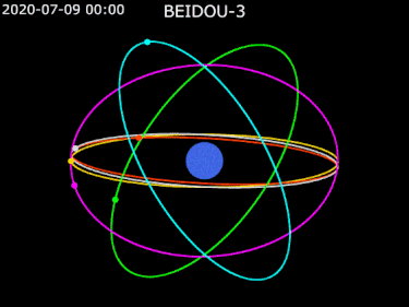
The latest generation called BeiDou-3 has 35 satellites with the last one being launched on 23 June 2020 and will serve users all over the world.
Characteristics
BDS possesses the following characteristics:
- Its space segment is a hybrid constellation consisting of satellites in three kinds of orbits. BDS operates more satellites in high orbits to offer better anti-shielding capabilities, which is particularly observable in terms of performance in the low-latitude areas.
- BDS provides navigation signals of multiple frequencies, and is able to improve service accuracy by using combined multi-frequency signals.
- BDS integrates navigation and communication function, and possesses multiple service capabilities, namely, positioning, navigation and timing, short message communication, international search and rescue, satellite-based augmentation, ground augmentation and precise point positioning, etc.
In addition to these there are also regional satellite systems that contribute to the overall GNSS network.
IRNSS/NavIC
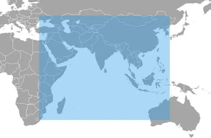
The Indian Regional Navigation Satellite System (IRNSS), with an operational name of NavIC (Navigation with Indian Constellation), is an independent regional navigation satellite system. It is developed by Indian Space Research Organization (ISRO). It provides real-time positioning and timing services. It covers India and a region extending 1500 km around it.
The Indian Regional Navigation Satellite System (IRNSS), with an operational name of NavIC (Navigation with Indian Constellation), is an independent regional navigation satellite system. It is developed by Indian Space Research Organization (ISRO). It provides real-time positioning and timing services. It covers India and a region extending 1500 km around it.
IRNSS will provide two types of services, namely,
Standard Positioning Service (SPS): It is provided to all the users and
Restricted Service (RS): It is an encrypted service provided only to the authorized users.
It consists of 7 satellites that have been in orbit since 2018 and operates at a frequency from 1176.45 to 2492.028 MHz.
QZSS
The Quasi-Zenith Satellite System, or QZSS, is a satellite navigation system from Japan. It is designed and operated by Japan Aerospace Exploration Agency (JAXA). It was launched to complement existing global navigation satellite systems, such as GPS. QZSS operates in the frequency from 1176.45 to 1575.42 MHz. It is compatible with GPS and ensures a sufficient number of satellites for stable, high-precision positioning over Japan and in the Asia-Oceania region.
The evolution and expansion of GNSS satellite constellations have transformed the way we navigate and interact with the world. Whether guiding a ship through open waters, ensuring the timely arrival of a package, or supporting emergency responders in times of crisis, GNSS satellite constellations are the unsung heroes navigating our modern world.
