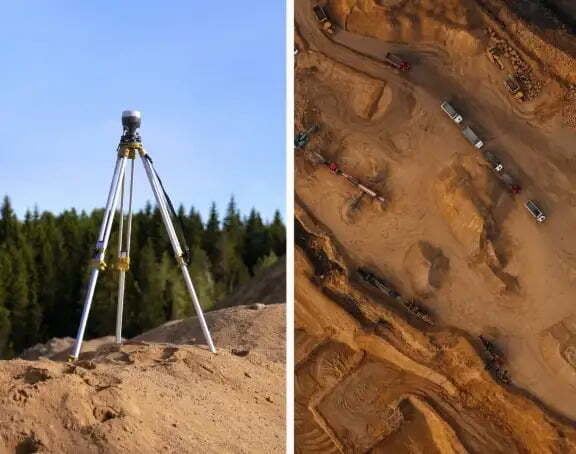
Volumetric measurements are done using aerial or ground surveying techniques to calculate the volume of stockpiles and other materials. Conventionally, it was done on the ground using total station but now, as an alternative, aerial UAVs are used to find the measurements. Surveyors now use drones to calculate the stockpile volume and amount of material removed from the ground. They plan accurate projects at different timeframes, and measure excavations. Surveys are done on the mine, quarry, landfills, coal yards, etc.
Advantages over traditional ground-based volumetric measurement
- Low Risk: When traditional methods are used, the surveyors have to take points in risky areas of the field, while in aerial surveys, it is easy to take points from inaccessible and dangerous places.
- Point Collection:The drone-generated point clouds gather millions of points compared to the hundreds gathered in a ground-based survey.
- Flexible, Fast, and Time Saving:It reduces the time surveyors spend on the field.
- Accuracy: It is more accurate when compared to traditional methods.
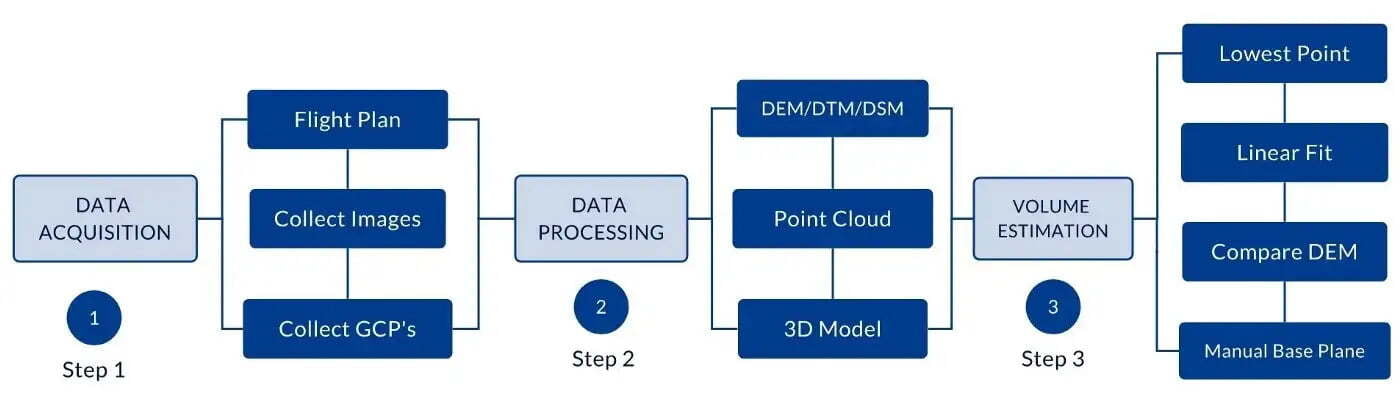
There are several methods for calculating the volume. The most straightforward technique uses Digital Terrain Model (DTM)/ Digital Surface Model (DSM). The Aerial surveying method generates aerial photography, which in turn is used to create Digital Terrain / Digital Surface models. Finally, the volume is calculated with the help of the software.
There are several methods for calculating the volume. The most straightforward technique uses Digital Terrain Model (DTM)/ Digital Surface Model (DSM). The Aerial surveying method generates aerial photography, which in turn is used to create Digital Terrain / Digital Surface models. Finally, the volume is calculated with the help of the software.
Before moving on to the Volumetric calculation, you have to be familiar with some terms given below.
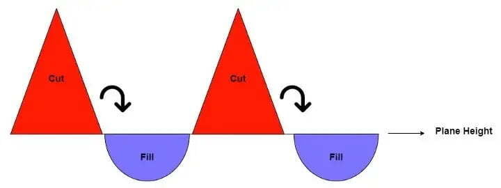
Cut Volume: The cut is the portion above the base plane. In simple terms, the Earth is removed from an area.
Fill Volume: The fill is the portion below the base plane. In simple terms, the Earth is brought to an area.
Plane Height: It refers to the height of the plane. All volume above or below the plane will be calculated for the plane height.
Volume Calculation
The volume measurement tool available in Surveyaan Geoworkspace calculates the volume with the Digital Surface model (DSM)/Digital Terrain Model (DTM).
The Digital Elevation Model is a 3D representation of the terrain elevations on the earth’s surface.
The Digital Terrain Model is a subset of DEM and consists of the earth’s surface and excludes buildings, trees, etc.
The Digital Surface Model is a subset of DEM and consists of the earth’s surface, including all objects like buildings, trees, etc.
The Digital Terrain Model is generally used for the volume measurements since it only contains the terrain. Any photogrammetry software can be used to find the volume measurements, and here I have used Surveyaan Geoworkspace.
In Surveyaan Geoworkspace, there are four Base Elevation Methods.
Let’s look at them one by one:
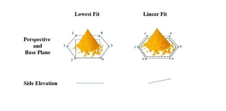
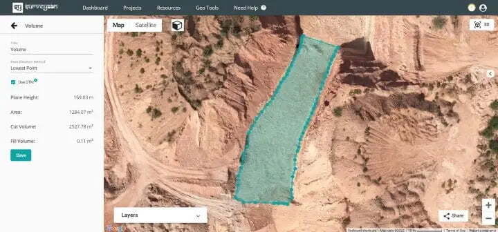
Lowest Point: Among all the points in the polygon, the point with the lowest elevation is considered. A horizontal base plane is created at the lowest elevation point, and the cut and fill volume is calculated accordingly. The lowest point is used to calculate the volume of the stockpiles when it is flat ground.
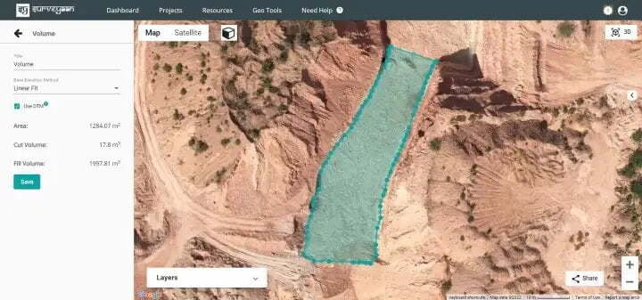
Linear fit: Concerning the points in the polygon, a linear fitted plane will be considered, and the plane that fits the best will be used for calculating the volume. The linear fit is used to calculate the volume of stockpiles whenever the ground underneath the stockpiles is sloped or irregular.
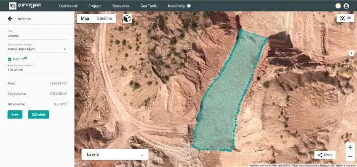
Manual Base Plane Method: In this method, we have to select the base plane manually, and the volume is calculated using that. It creates a horizontal plance according to the height of the base plane entered.
Initially, we need to have the base elevation of the area. Here I have a known base elevation of 170.48096 m, and I have entered the known elevation in the Base Elevation field and clicked on the Calculate button to get the volume.
The last method is the Compare Dem Method. Before moving on to that, we need to be clear on Volumetric Survey using the Pseudo GCP Method.
We need GCP to improve the accuracy of our projects. One interesting point is that even without the help of DGPS, volume can be measured accurately. We use our self-devised Pseudo GCP method for volumetric survey.
Workflow
- Place at least 4–5 GCPs at the site. Make sure they are not placed at the location where Volumetric Survey needs to be conducted.
- Fly the drone and collect Raw photos.
- Keep the GCPs in the same place for the next time.
- Process the collected dataset in any photogrammetry software.
- Now, you have the initial Survey results, and you get the GCPs values too.
- Suppose you want to survey after 15 days. So, you go to the same site again. Ensure all the GCPs are placed at the exact location and fly the drone.
- This time, process the dataset using the GCP method. You can get the values of GCPs from the initial survey. This step would ensure that both topographical surveys have been conducted at the same base.
- Once processed, you can easily find the relative Cut and Fill volume.
Since we know the Pseudo GCP method, let us look at the final volume method.
Compare DEM: This method compares similar projects done at the same place in different time frames. Here we can select an existing project from the drop-down, and it automatically calculates the volume measurements.
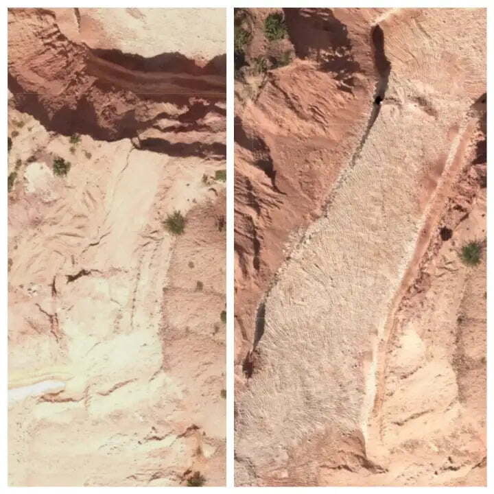
Here in Figure 8 above, you can see two project photos. The photo on the left is the area surveyed first and to the right is a photo of the same area surveyed after one month.
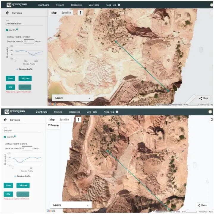
In Figure 9 above, you can see two project photos with elevation profiles. The image on the top is the area surveyed first, and the bottom is a photo of the same area surveyed after one month. To compare the volume between such projects, follow the steps below:
- Select Compare Dem from the Base Elevation Method, select the project you need to compare from the Select Project field, and it automatically calculates the volume measurements.
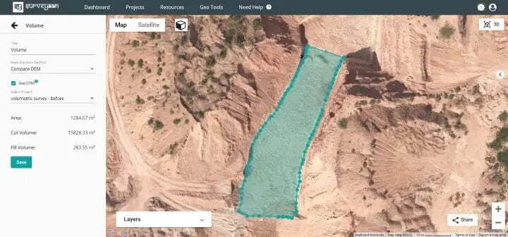
In Figure 10 above, the project surveyed first has been selected from the dropdown of the Select Project field. Here the selected polygon is the area of the project that has been surveyed after one month and the selected polygon acts as the base plane. The cut volume here refers to the earth removed from the ground. As we can see the cut volume is more here since this marked area has been dug up.
This brings to the end of the blog. I hope this article gained some knowledge on measuring volumes using different base plane methods.
Give your response and stay connected for more.
Thanks for reading.
