The Government has updated the Standard Operating Procedures (SOP) for drone surveys and submission of Digital Aerial Images of Mining areas to the Indian Bureau of Mines. Let’s see what has been updated under the new SOP.
IBM has updated the Ground Control Points. With a certified DGPS instrument, the mine should establish at least 5 GCP per sq km of the lease area. An example is also provided to aid comprehension. If the leased area is 478 ha, a minimum of 24 GCPs, including three permanent GCPs, should be placed within the leased area.
The updated SOP has also given more comprehension of the leased area covered with thick canopies. It is not possible to place GCPs in areas filled with dense canopies within the leased area. In such leased areas with dense canopy parts, GCPs can be reduced proportionally and distributed well in the remaining parts of the leased area. E.g., If 200 ha of the 478 ha lease area is covered with a thick canopy, then 14 GCPs, including three permanent GCPs, must be established in the remaining 278 ha.
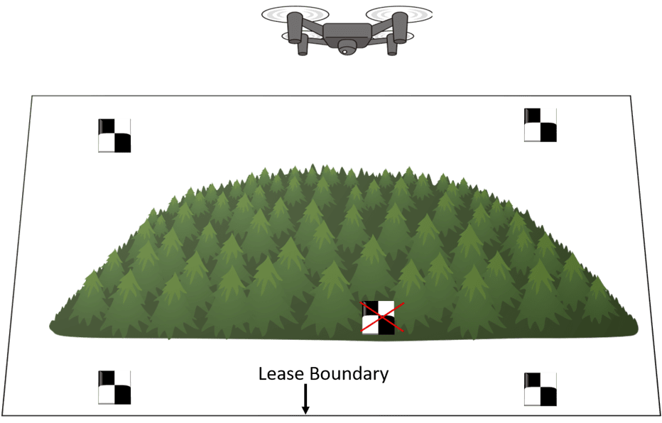
The figure above shows a leased boundary containing part of a canopy. It is not possible to place GCPs in areas filled with dense canopies. So here, the GCPs are distributed well in the remaining parts of the leased boundary.
The data outputs needed to be provided to IBM by the lessee have also been updated. The updated data outputs are discussed one below the other.
- The Orthomosaic image should include a buffer zone of 100m, and it should be a single image.The spatia resolution of the image has also been defined, which should be less than or equal to 5 cm in UTM Projected Coordinate System and in Geotiff format.
- The previous SOP only mentioned submitting the Digital Elevation Model (3D), i.e., Digital Surface Model and Digital Terrain Model. In the new updated SOP, it has been made clear that the Digital Elevation Model (3D), i.e., Digital Surface Model and Digital Terrain Model, should include the 100m buffer zone. The spatial resolution of the image has also been defined, which should be less than or equal to 15cm in UTM Projected Coordinate System and in Geotiff format.
Compared with the Previous SOP, the new updated SOP clearly defines the GCPs that must be submitted to IBM. The new updated SOP has divided the GCPs that must be submitted to IBM into three files.
- The total GCPs DGPS Survey data, including permanent GCPs, must be submitted to IBM in GCS WGS-84 datum and UTM Projected Coordinate System in Excel Format.
- The Permanent GCP data needs to be submitted to IBM both in GCS WGS-84 datum, and UTM Projected Coordinate System in Excel Format.
- The plan of GCPs needs to be submitted to IBM in UTM Projected Coordinate System in shapefile format.
- In the new SOP, submitting the RMSE report in .txt, .doc, and .pdf format has been mandatory. Earlier, the RMSE report needed to be submitted only in .txt and .doc format.
- There are also major updates in the map of the mining lease area. More features have been added to the map that needs to be marked in the map before submitting it to IBM. The updated features are listed below.
- 1. ML Boundary
- 2. Topsoil stack
- 3. Infrastructure
- 4. Roads
- 5. Railways
- 6. Tailing Pond
- 7. Effluent Treatment Plant
- 8. Mineral Separation Plant
- 9. Township Area
- 10. Others to specify (Green Belt area)
The data should be submitted in the UTM Projected Coordinate System in the shapefile format in polygon geometry along with the associated files. The above-mentioned applicable land use data needs to be provided in a single shape file with proper nomenclature of features in the attribute data of the shape file.
In the previous SOP, the Boundary Pillar coordinates must be submitted in the shapefile and Excel format in Geographic Coordinate System and Projected Coordinate System. In the new updated SOP, the boundary pillar coordinates must be submitted in Excel format in GCS and UTM. Also, a plan of the leased boundary pillar coordinates also needs to be submitted in UTM and GCS in WGS 84 datum. Although here, two separate shapefiles for GCS and UTM must be submitted.
Finally, As per the previous SOP, the Drone Survey Log Sheet needed to be submitted only in the .doc format, while in the new updated SOP, it has been made clear that the drone survey log sheet needs to be submitted both in .doc and pdf format.
As per the updated SOP, the processed output data must also be submitted to the State Governments. It had to be submitted to the Chief Mining Geologist and the Respective Regional Offices of IBM earlier.
