Ground Control Points (GCPs) are defined as the points on the surface of the earth which help to georeference raster data such as satellite, aerial, or drone imagery. They help in high-precision drone mapping. GCPs reduce the margin of error from a scale of meters to centimeters.
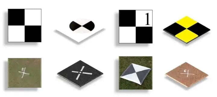
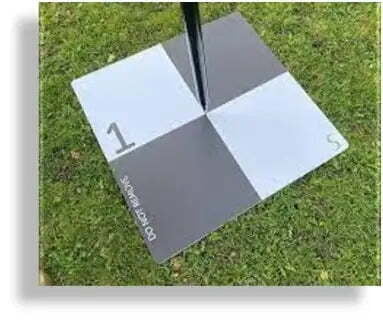
They usually look like checkboard and are marked on the ground. They are marked with black and white color because it is easy to spot from high altitudes. They are also marked with numbers so that it is easy to identify them.
How to create GCP Placement?
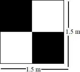
- The individual GCPs should have a size of at least 1.5 meter x 1.5 meters so that it is visible from a higher altitude.
- The GCP points should be spread out evenly throughout the map so that the raster data is geo-referenced properly.
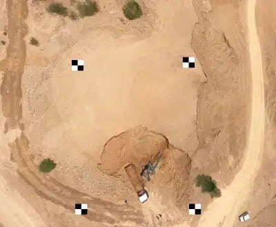
- The GCP should be clearly visible and unobstructed.
- A minimum of 3 GCPs are required.
- You can use black spray paint on a white background and mark the GCPs using the “X” sign. Also, make sure to mark a number next to each point to assist with identification at the time of processing.
- If spray paints are not available, you can always use Lime or similar stuff to mark on the ground.
What if Printed Banners are not available?
How is GCP measured?
Surveyors use a surveying instrument known as DGPS (Differential Global Positioning System) to place on the center of the GCP point and note down the accurate data and preserve it in the logbook.
Surveyors use a surveying instrument known as DGPS (Differential Global Positioning System) to place on the center of the GCP point and note down the accurate data and preserve it in the logbook.
Why do we need GCPs?
GCPs can be considered reference points. To know why we need GCPs, we need to know what accuracy is.
Accuracy is how close a given set of measurements are to their true value.
There are two types of accuracy:
Absolute accuracy is derived from comparing the position of real-world point data to the position of the data points within a processed map. For example, the absolute accuracy is high if a point, let’s say, a house or a road is matching the exact location with the real-world data.
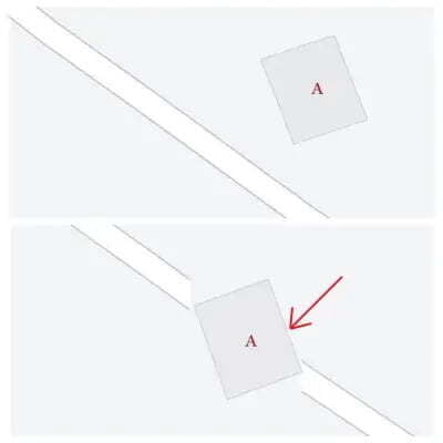
Here in Fig above, Imagine A is a house nearby a road in the real world (left) and to the (right) is the processed map. On the map, the house is positioned in the middle of the road. Here the map has an absolute error as the house is in the wrong place.
Relative accuracy is the degree to which a given point on a map is accurate relative to other points within that same map. For example, the relative accuracy is high if two points have the same distance between them on the processed map, and in reality.
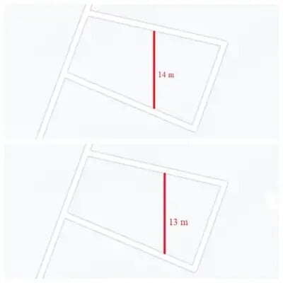
Here in Fig above, Imagine the distance between the 2 roads to be 14 m in the real world. If the distance between these 2 roads in the processed map is also the same, then we can say that there is no relative error.
This is why we need GCP points for making maps with high absolute and relative accuracy.
Whether or not, we need to plan GCP for a project depends on the use case. If the use case is just to take measurements of objects you don’t need GCPs but if the use case is related to land surveys in need of positional accuracy, then we need GCPs.
When and where to use GCP?
As you know they are also known as reference points, GCP points are also used to create a model or replica of the world terrain. GCPs are primarily used in projects that exclusively demand precision mapping like construction, mining, topographic surveying, etc. If your project requires a high degree of global accuracy, then you should use ground control points.
Generally, per sq. km or 100 Hectares, 4–5 GCPs are more than sufficient to geo-reference raster data. The thumb rule of placing the GCP is that wherever there’s an abrupt change in the terrain, you can place the GCP, and also GCPs should be spread out uniformly throughout the terrain
GCP Accuracy
With the help of any Photogrammetry Software, we can get a detailed GCP report. For those of you who are not familiar with what RMSE is, Root Mean Square Error or RMSE is used to measure the difference between 2 values or datasets. Here the first dataset is the error value obtained from the GCP points in the ground and the second dataset is the error value obtained after processing in the Photogrammetry Software.
With the help of any Photogrammetry Software, we can get a detailed GCP report. For those of you who are not familiar with what RMSE is, Root Mean Square Error or RMSE is used to measure the difference between 2 values or datasets. Here the first dataset is the error value obtained from the GCP points in the ground and the second dataset is the error value obtained after processing in the Photogrammetry Software.
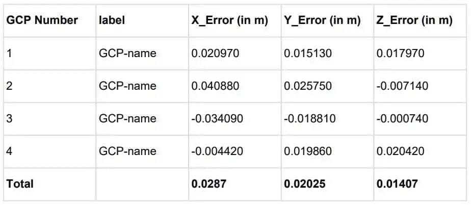
Here in this report, we can view the GCP number, GCP label, and Error-values obtained.
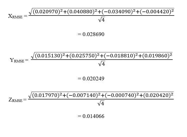
Now let us see how to calculate the RMSE. The formula for calculating the RMSE error is
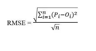
Where:
Pi = Predicted Value, Oi = Observed Value, n = Number of Observations
(Pi — Oi) = Here the X, Y, and Z errors are the difference between the Predicted and Observed values
N = 4
Hope this article gained some knowledge for you!
Thanks for reading.
