Standard Operating Procedure (SOP) addresses guidelines for the drone pilot to follow during flight, pre-flight and post-flight procedures to ensure the highest degree of safety. Each lessee must provide IBM with the data output for the previous financial year.
10. Data Output and Formats
The outputs that need to be submitted are discussed below:
The outputs that need to be submitted are discussed below:
Orthomosaic
Orthomosaic is a large, high-resolution map-quality image that combines many smaller images called orthophotos. Submitting the orthomosaic image of the leased boundary to IBM is mandatory. As a reminder, the orthomosaic of the leased boundary should also incorporate a 100m buffer zone. The buffer zone is included to monitor the environmental impact and ascertain any excavation therein. The data should be submitted in a GEOTIFF format.
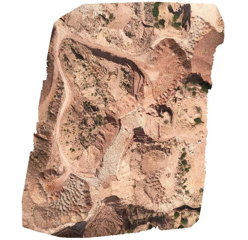
The figure above shows the Orthomosaic map in Geotiff format.
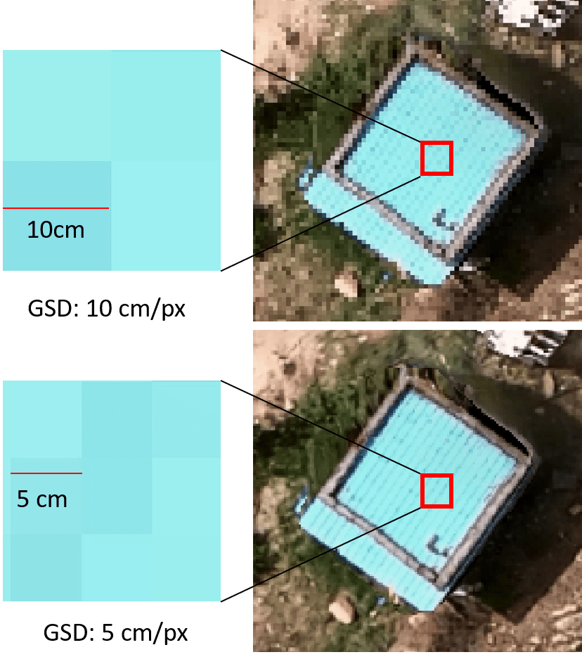
Make sure the Ground Sample Distance (GSD) is less than 5 cm per pixel or 5cm per pixel.
GSD is the distance between the centers of two successive pixels on your map, measured in inches, centimeters, or millimeters. A drone can measure with a GSD of 5 cm/px, meaning that each pixel on your digital map represents 5 centimeters of actual space in the real world.
Digital Elevation Model (3D) — DSM & DTM
The Digital Elevation Model is a 3D representation of the terrain elevations on the earth’s surface.
The Digital Terrain Model is a subset of DEM and consists of the earth’s surface and excludes buildings, trees, etc.
The Digital Surface Model is a subset of DEM and consists of the earth’s surface, including all objects like buildings, trees, etc.
While submitting to IBM, ensure the DSM and DTM are in GeoTif format.
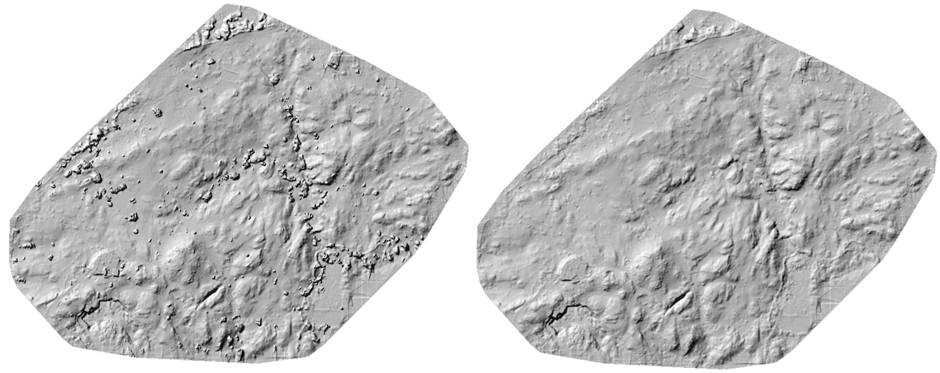
The Figure above shows the Digital Surface Model and Digital Terrain Model in GeoTif format.
The resolution of the Digital Elevation Model (DEM) should be 15 cm per pixel or better.
Ground Control Points
Ground Control Points (GCPs) are the points on the earth’s surface that help georeference raster data such as satellite, aerial, or drone imagery. The GCP data should be submitted to IBM in shapefile and Excel format.
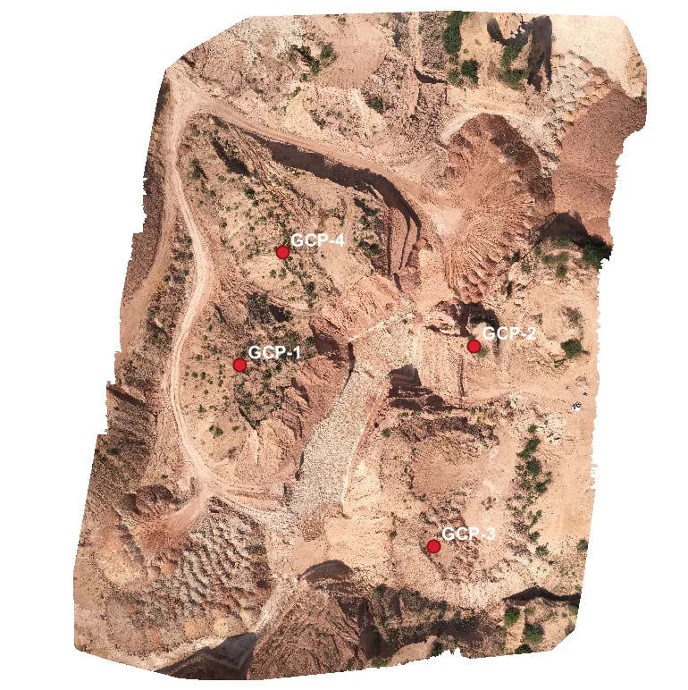
The figure above is an Orthomosaic image in GeoTif format. The red points are the Ground Control Points overlaid on the orthomosaic file in shapefile (SHP) format.
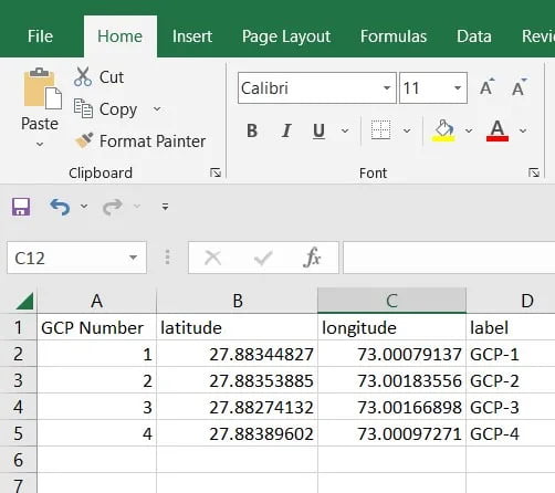
The figure above shows the GCP data in Comma Separated Value (CSV) format.
RMSE Report
RMSE is used to measure the difference between 2 values or datasets. Here, the first dataset is the error value obtained from the GCP points in the ground, and the second dataset is the error value obtained after processing in the Photogrammetry Software. With the help of any Photogrammetry Software, we can get a detailed GCP report. I have generated the report using Surveyaan Geoworkspace. The RMSE report should be submitted to IBM either in .txt or in .doc format.
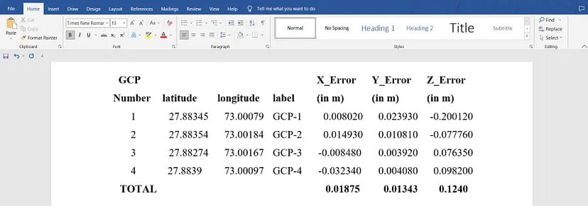
From the figure above, we can view the GCP report in .doc format.
Map
The lessee should submit the map of the mining lease to IBM showing area of;
a) actual excavation (mineral and waste)
b) Mineral storage
c) Subgrade dump
d) Waste dump
e) Afforestation
f) Backfilled, reclaimed, and rehabilitated area
within the lease for the preceding financial year. The data should be submitted in the UTM Projected Coordinate system in shp format.
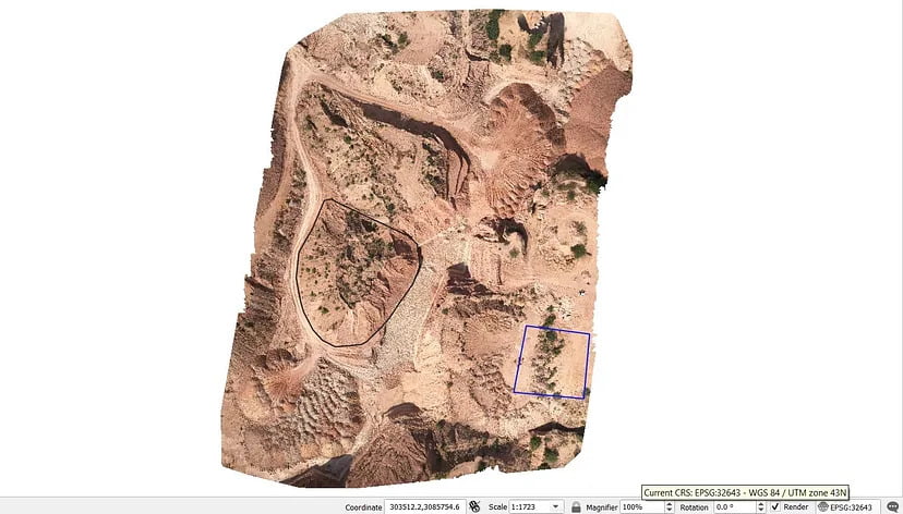
In the figure above, the black shape shows the waste dump, and the blue shape shows the reclaimed area. Both are in Shapefile (shp) format and in UTM Projected Coordinate System.
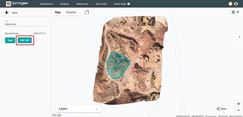
In the figure above, the area is calculated from the Surveyaan Geoworkspace using the Area tool in the Measurement Tools. The measurements are then saved with a suitable name. The shapefiles are then generated then using the DXF SHP export button.
Boundary Pillar
It helps in identifying the mining boundary and also helps to prevent encroachment. Unique identification numbers also mark the pillars. With the help of the DGPS, the coordinates of the pillars are noted. The Boundary pillar data should be submitted to IBM in shapefile (shp) and Excel.
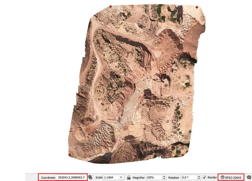
In the figure above, the red points show the boundary pillars’ position. Here the points are in shapefile (shp) format and are in UTM Projected Coordinate System.
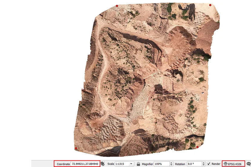
In the figure above, the red points show the boundary pillars’ position. Here the points are in shapefile (shp) format and are in Geographic Coordinate System.
Drone Survey Log Sheet
The drone survey log sheet consists of general checking fields like the airspace map, wind speed, cloudiness etc. It also contains the flight log where information on each flight including the date, place and time of operation are recorded. The drone survey log sheet should be submitted to IBM in .doc format.
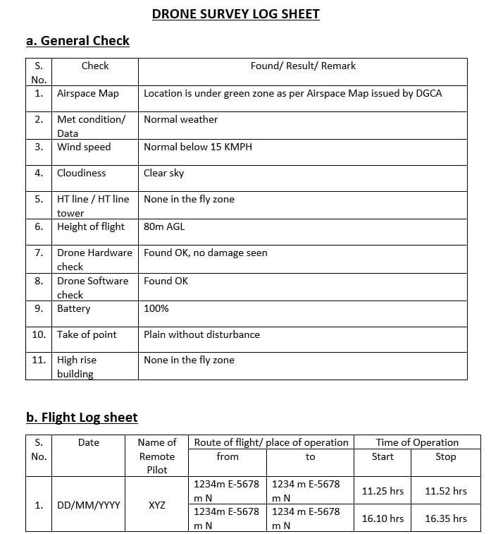
The figure above, is kind of a General Log Sheet and IBM has not defined any standard format for it.
11. Submission of Data to IBM
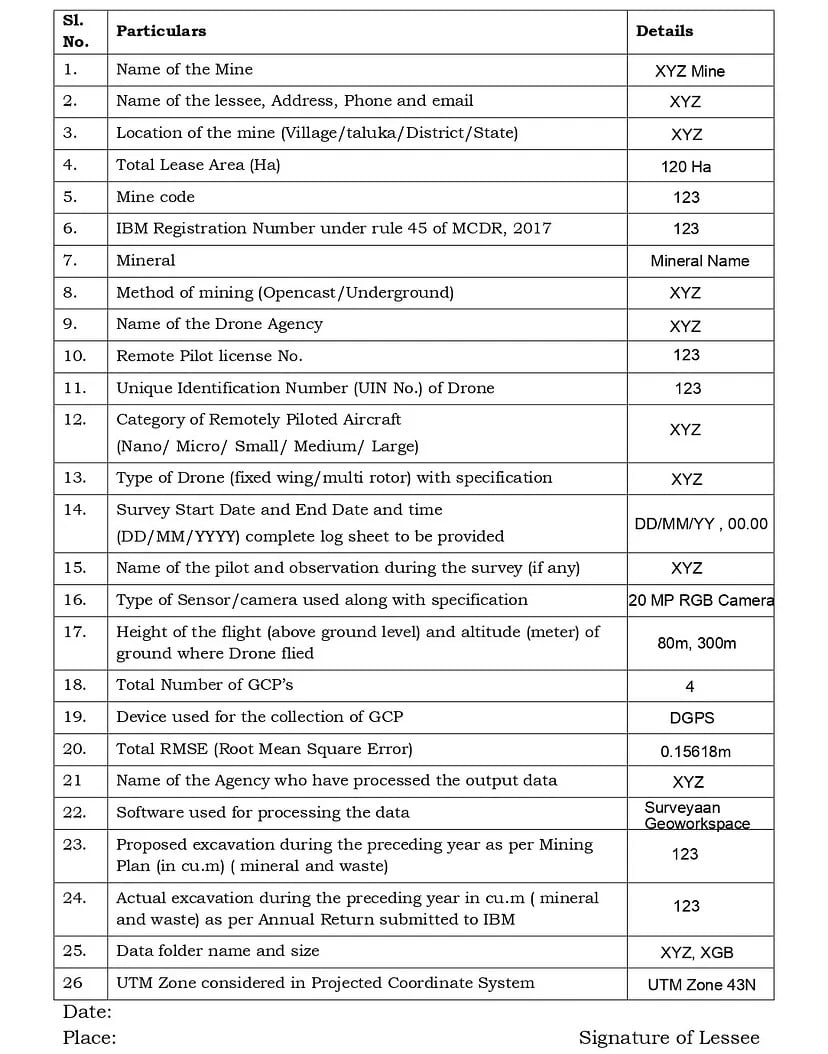
The processed output data of the drone survey shall be submitted in soft copy only in storage media (i.e., external hard disk) on or before 1st July every year along with the Output data submission form at the following addresses.
- The Chief Mining Geologist, Indian Bureau of Mines, GM&MM Cell, 1st Floor, A- Block Indira Bhavan, Civil Lines, Nagpur- 440001, Maharashtra
- Respective Regional Offices Indian Bureau of Mines
You can edit text on your website by double clicking on a text box on your website. Alternatively, when you select a text box a settings menu will appear. your website by double clicking on a text box on your website. Alternatively, when you select a text box
You can edit text on your website by double clicking on a text box on your website. Alternatively, when you select a text box a settings menu will appear. your website by double clicking on a text box on your website. Alternatively, when you select a text box
