Volumetric surveys are topographical surveys that accurately quantify the volume of material removed from or placed at a location. It is basically done by comparing two surveys conducted at the same place at different point of time. They are performed for several reasons, such as obtaining volumes of material stockpiles, determining required fill, or calculating the amount of material removed from a site.
When using a drone to conduct survey, we require GCPs to improve the accuracy. Placing GCPs itself is a very tedious task and taking measurement using DGPS or Total Station is little time consuming. Alternatively, we can use RTK drones to improve the accuracy but they come at a hefty price.
We, at Surveyaan, have devised a new method to escape from taking measurement using DGPS or Total Station. We can easily conduct Volumetric Survey using so-called Pseudo GCP method.
Workflow
- Place at least 4–5 GCPs at the site. Make sure they are not placed at the location where Volumetric Survey needs to be conducted.
- Fly the drone and collect Raw photos. We would advise you to fly with Surveyaan ONE.
- Keep the GCPs at the same place for the next time.
- Process the collected dataset in your favourite Photogrammetry software.
- Now, you have the initial Survey results and you get the GCPs values too.
- Suppose, you want to conduct the survey after 15 days. So, you go to the same site again. Make sure all the GCPs are placed at the same location and fly the drone.
- This time, process the dataset using GCP method. You can get the values of GCPs from the initial survey. This step would ensure that both the topographical surveys have been conducted at the same base.
- Once processed, you could easily find the relative Cut and Fill volume.
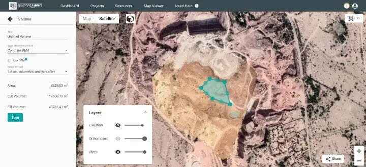
- Select the Second Survey (which was conducted after 15 days).
- Select Volume in Measurement Tools.
- Select Compare DEM as Base Elevation Method.
- Optional, check the DTM checkbox.
- Select the Initial Survey Project Name.
Volume Calculation using Surveyaan GeoWorkspace