The Government released several sets of instructions to allow the operation of UAV drones called the Standard Operating Procedures (SOP) for carrying out drone survey and submission of Digital Aerial Images of Mining areas to Indian Bureau of Mines.
What is an SOP?
SOP stands for Standard Operating Procedure. A standard operating procedure is a document that contains step-by-step instructions and guidelines for employees to follow when performing a technical, repetitive process within an organization. SOPs are employed by a number of organizations to guarantee that tasks are carried out consistently, effectively, and with the least chance of error or omission.
SOP stands for Standard Operating Procedure. A standard operating procedure is a document that contains step-by-step instructions and guidelines for employees to follow when performing a technical, repetitive process within an organization. SOPs are employed by a number of organizations to guarantee that tasks are carried out consistently, effectively, and with the least chance of error or omission.
Standard Operating Procedures for carrying out drone survey and submission of Digital Aerial Images of Mining areas to Indian Bureau of Mines
1. Drone Agency Registration and Permissions
There is no need to register with IBM for drone survey in mines. Drone Agencies or the lessee can conduct the survey while following all the applicable rules, regulations and guidelines notified by DGCA. Check the Airspace map from the Digital Sky website. The drone airspace map is an interactive map of India that demarcates the red, yellow and green zones across the country.
Green zones are the unrestricted zones where drones can be operated without any permission
Yellow zones are controlled zones and the drone can only be operated after a permission from DGCA.
Red zones are highly restricted zones and can be operated only after permission from the authorities.
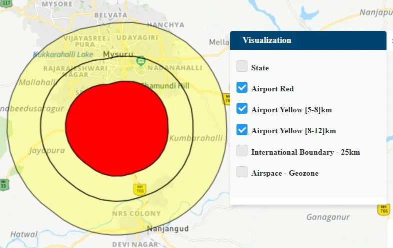
From Airspace Map of India above, In the Airport Yellow [8-12 km] zone , drones can be operated only upto 60m. In the Airport Yellow [5-8 km] zone and Airport Red zone , drones can be operated only after permission from DGCA.
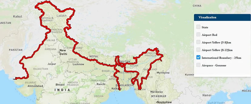
From the figure as shown above, we can see that this is the International Boundary. This is a highly restricted zone.
2. Drone Specification
Drones used for the survey should follow DGCA guidelines and should possess mandatory safety features as notified by DGCA from time to time.
3. Sensor/Camera Specification and output data resolution
The drone should have a minimum 20 megapixel or higher resolution RGB camera with the capability to capture high-quality undistorted pictures. Camera should have the resolution to capture the images less than 5 cm Ground Sample Distance or 5 cm per pixel. The resolution of Digital Elevation Model should be 15 cm/pixel.
4. Drone flying path and flying height
The path plan should be such that there is enough overlap between the photos. The front overlap should be minimum 80% and side overlap should be minimum 70%. The flight altitude should be as per DGCA prescribed limits. The camera angle should be kept at 90° vertically downwards.
5. Survey Area
The survey should cover the entire mining lease area capturing all mining, allied activities and 100m beyond periphery of the mine lease boundary to monitor the environmental impact and ascertaining any excavation therein. The flight path plan and the numbers of flights taken to cover the entire area shall be provided to IBM along with the output data. For leases having common mine boundary, the survey may be limited up to the lease boundary for the sides, the lease shares common boundary with another lease.
6. Ground Control Point for Drone Surveys
Each mine must establish at least 5 GCPs per sq. km of lease area with a certified DGPS instrument before undertaking the drone survey. If area is less than 1 sq.km, 4 GCPs are only needed.
Points to Note while placing GCPs:
- GCP must be easily visible.
- It should be well distributed all over the area.
- Dimensions: Minimum 50cm by 50cm and mark X with contrast colors
- Increase the size of the GCP depending at which height you fly.
- The Root Mean Square (RMS) Error should be less than 5cm.
- At least 3 GCPs must be placed permanently at undisturbed locations and has to be covered in subsequent surveys to cross check the error.
- Boundary pillars shouldn’t be considered as permanent GCPs.
7. Drone Survey Time
It is advised to fly the drone in better conditions when the sky is clear and the sun is overhead to minimize the shadows in photographs. Do not fly the drone when it is rainy or windy.
8. Co-ordinate Reference System
The Co-ordinate Reference System of the photos captured and used in drone survey should be in (Latitude, Longitude) with WGS84 Datum and Decimal Degrees/Degree Minute Seconds as unit.
To find the coordinates of the photo used in the drone survey, right click on the image and got to Properties and then switch to the Details tab and scroll down to the GPS section.
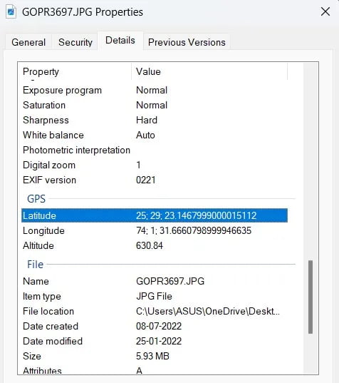
From the Figure above, these are the photos captured by the drone and here you can see that the (Latitude, Longitude) values are in Degree Minute Second (DMS).
The Orthomosaic shall be submitted in the Universal Transverse Mercator (UTM) and unit as meters.
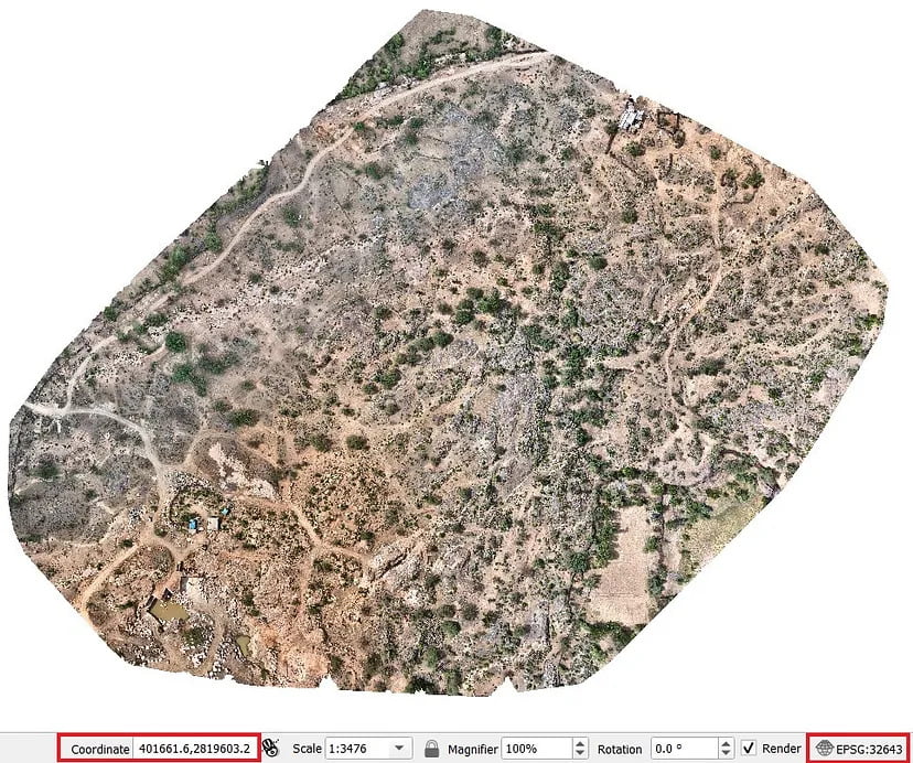
From Figure above, this is an orthomosaic file and here it is in UTM Coordinate Reference System having EPSG Code: 32643 and the coordinate values are in meters.
The GCPs survey data and boundary pillar coordinates shall be submitted in (Latitude, Longitude) with WGS84 Datum and Degree Minute Seconds as unit.
The precision of the data submitted in (Latitude, Longitude) with WGS84 Datum should be in format as (DD MM SS.SSSSSS)
From Figure above, it shows the properties of an image used in drone survey. Here the (Latitude, Longitude) values are in Degree Minute Second (DMS) and in the seconds value you need to have precision upto 6 digits.
9. Preservation of Raw and Processed Data
The raw and processed data of each survey must be kept safely with the lessee for a minimum period of five years. The data must be submitted to IBM in case required by IBM for verification at any stage. The data can be stored in cloud platforms such as Surveyaan Geoworkspace, so that there is no risk of getting the data lost or corrupted.
Now, we will continue in the next blog mentioning about the data outputs and formats needed to be submitted to IBM.
