In this blog post, we will explore the concepts of Longitudinal and Cross sectioning, their applications, and the benefits they offer in surveying.
Longitudinal Sectioning
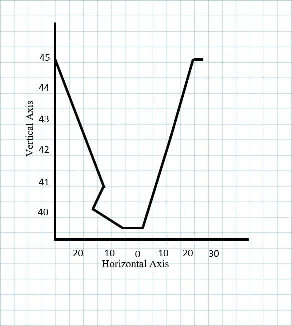
Longitudinal sectioning, also known as profile leveling or profiling, is the process of establishing the elevation of sites on the ground at about regular intervals along a continuous line. Profile levelling is one of the surveyor’s most typical applications of running levels and vertical distance measuring. The data are represented as a profile, which is a representation of a vertical cross section. The primary objective of longitudinal sectioning is to determine the slope, grade, and vertical alignment of the surveyed feature.
Longitudinal sectioning, also known as profile leveling or profiling, is the process of establishing the elevation of sites on the ground at about regular intervals along a continuous line. Profile levelling is one of the surveyor’s most typical applications of running levels and vertical distance measuring. The data are represented as a profile, which is a representation of a vertical cross section. The primary objective of longitudinal sectioning is to determine the slope, grade, and vertical alignment of the surveyed feature.
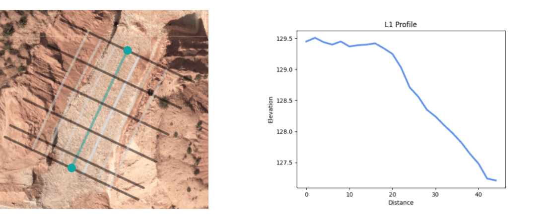
The process of creating a longitudinal section typically involves the following steps:
- Establishing a base line: A straight line is marked along the path of the feature being surveyed. This line serves as the reference for all subsequent measurements.

- Taking elevation measurements: At regular intervals along the base line, surveyors measure the elevation of the ground surface using an instrument like a leveling instrument or a total station. These measurements are recorded to create a profile of the land.
- Plotting the profile: The collected elevation data is plotted on graph paper or entered into specialized software to create a longitudinal section. The resulting graph shows the variations in ground level along the surveyed line.
Cross Sectioning
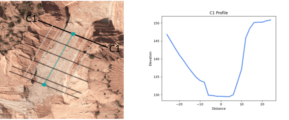
Cross sectioning involves the creation of horizontal cross-sectional views of the land perpendicular to the alignment being surveyed. This technique provides valuable information about the terrain’s shape, dimensions, and features at specific locations. Cross sections are particularly useful for designing and analyzing infrastructure elements like roads, canals, or embankments.
Cross sectioning involves the creation of horizontal cross-sectional views of the land perpendicular to the alignment being surveyed. This technique provides valuable information about the terrain’s shape, dimensions, and features at specific locations. Cross sections are particularly useful for designing and analyzing infrastructure elements like roads, canals, or embankments.
The process of creating a cross section typically involves the following steps:
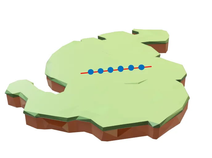
- Establishing cross-section lines: Surveyors mark perpendicular lines to the alignment being surveyed at regular intervals. These lines are known as cross-section lines or station lines.
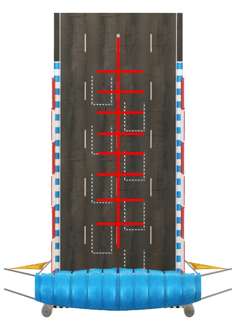
- Taking measurements: Along each cross-section line, surveyors measure the ground level at predetermined intervals using leveling instruments or total stations. Additional measurements may be taken for features such as buildings, utilities, or natural elements.
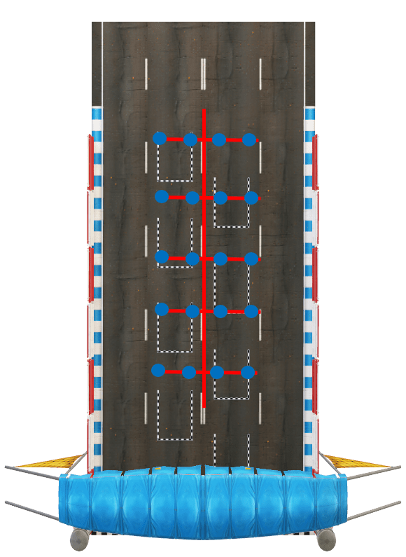
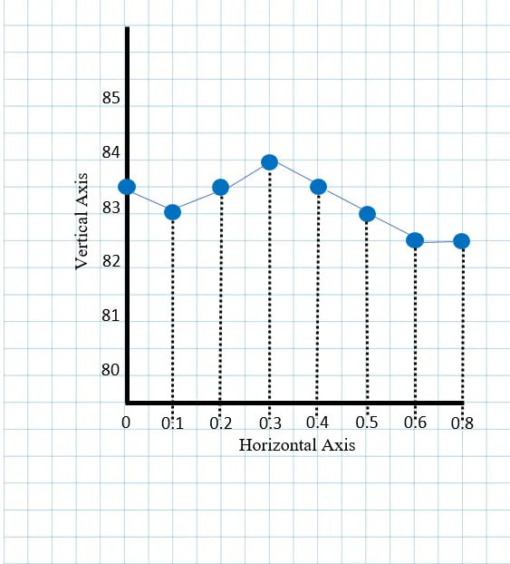
- Plotting the cross section: The measured data is then plotted on graph paper or entered into specialized software to create a cross section. The resulting diagram provides a detailed view of the land’s features and elevations along the surveyed line.
Applications
Longitudinal and cross sectioning have numerous applications in surveying and civil engineering projects:
- Road construction: Longitudinal and cross sectioning techniques are extensively used in road surveys for designing alignments, establishing grades, and determining cut and fill quantities for earthwork calculations.
- Drainage systems: The creation of longitudinal and cross-sectional profiles helps in designing efficient drainage systems by identifying the natural flow patterns and locating appropriate points for channeling water.
- Utility infrastructure: Surveying utilities, such as pipelines or electrical cables, using longitudinal and cross sectioning helps in planning their alignment, estimating trench volumes, and identifying potential conflicts with existing infrastructure.
- Land development: When planning residential or commercial developments, longitudinal and cross-sectional surveys provide valuable information for site grading, building placement, and determining drainage patterns.
Benefits
- Accurate data: These techniques allow surveyors to gather precise elevation and terrain data, providing a solid foundation for engineering design and decision-making.
- Efficient design: Longitudinal and cross-sectional surveys facilitate the design of infrastructure elements, enabling engineers to optimize grades, alignments, and earthwork quantities.
- Enhanced visualization: The graphical representation of longitudinal and cross-sectional data helps stakeholders visualize the project’s topography and understand its impact on the construction process.
- Conflict identification: By identifying potential conflicts, such as steep slopes or underground utilities, early in the surveying process, longitudinal and cross sectioning help avoid costly design revisions during the construction phase.
Longitudinal and cross sectioning techniques play a vital role in surveying, providing valuable data for civil engineering projects. The detailed profiles and cross sections derived from these surveys aid in optimizing alignments, grades, and earthwork quantities while minimizing conflicts and ensuring efficient project execution.
